
Weather on Aconcagua
Weather on Aconcagua is variable like any high mountain, but is often cyclical, with short periods of adverse weather often lasting three days followed by longer periods of stable weather. The forecast for Santiago is often more indicative of what is to come to the mountain than the forecast for Mendoza due to the weather patterns coming in from the Pacific. There are clear indicators that can be seen from base camp, and it is important not to get caught out on summit day during a storm. The winds are extremely strong and it is very cold, with whiteouts common.
January and February have the best weather. Rain is rare at the high camps but precipitation in the form of snow is very common, with blizzards and whiteouts to be expected. Conditions at the high camps even in good weather are normally very cold, with temperatures at 0 degrees F when starting out for the summit before sunrise. Typical wind chill makes it much colder and frostbite is a near constant danger. However a clear windless day on Aconcagua is an absolute pleasure, and sometimes you can sunbathe at base camp. Be prepared for a wide diurnal temperature range, which is tiring, and potential for windburn and sunburn. Covering your face and protecting your extremities is important with these weather conditions.
Typical storms and bad weather on Aconcagua are generated by low-pressure systems called "vaguadas" that move eastwards from the Pacific Ocean. These are predicted by a warm front that precedes a cold one (the actual storm occurrence). Also, the Andes mountain range divides a western marine and an eastern continental climate, generating a mountain weather feature known as a Fohn effect (known regionally as Zonda or the viente blanco).
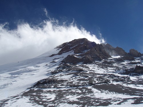
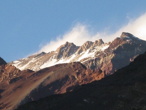
Windblown snow on the summit of Aconcagua is a common occurrence.
It is fairly easy to forecast the three factors which bring bad weather:
- a low-pressure system moving east from the ocean
- rain in Santiago
- local alterations of barometric pressure and cloudiness on the mountain
Always keep an eye out for the following occurrences:
* If a warm front arrives, prepare for a later cold front
* If a cold front from the Pacific arrives, there is a high probability of a storm on Aconcagua
* Changes in cloudiness, barometric pressure, the intensity of wind and wind direction all indicate a regional change of weather so be careful if you are planning your summit cycle for 4 days
Remember that the mountain generates its own climatic conditions that cannot be forecast. Typical cloudy phenomena begin with small cumuli that grow in size every hour to the south (watching from Plaza de Mulas down the Horcones valley), or northwest.
These clouds begin to appear between 2 and 4 pm, becoming completely cloudy in the evening and sometimes clearing after sunset. These first clouds appear earlier each day, and bad weather is established when they appear between 10 am and 12 pm.
Lensed stratocumuli and hooked cirrus also foretell bad weather, generally indicating a Zonda phenomenon, which means very strong winds and snow at high altitude. This is known as the viente blanco or white wind and is particularly dangerous. Big lensed stratocumuli appear as a hat or “mushroom" on the summit and is a clear confirmation that bad weather has arrived.
Predicting and analysing weather patterns are an important part of high-altitude mountaineering. Before you go, understand weather trends and what it will mean for your time on the mountain.
Analysing Pressure:
For calibration of altimeters Plaza de Mulas uses a constant value of 4260 m (13,976 ft). Normally pressure increases slowly from sunrise to midnight and diminishes again during the night.
If pressure reduces...
Slowly (1 to 2 hPa/day): this means bad weather coming, confirmed if, in addition, the temperature rises Slowly (1 to 2ºC/day, 2 to 4ºF/day) and/or ‘sheep’ clouds (cirrocumulus) are observed.
Abruptly (3 to 4 hPa/day): immediate and intense bad weather, confirmed if, in addition, temperature descends abruptly (3 to 4ºC/day, 5 to 7ºF/day).
Oscillating: long bad weather.
If pressure increases...
Slowly: this means good weather, confirmed if in addition temperature descends slowly and sky is clear or with medium and isolated cumulus. If increase starts from a normal pressure (between 599 and 601 hPa for Plaza de Mulas), good weather will last a period of time equivalent to the time pressure took in reaching its maximum value.
Abruptly: temporary improvement, confirmed if in addition temperature descends abruptly; or unstable weather.
Oscillating: improvement in the weather will be delayed.
If pressure remains stable...
In a low value (below 599 hPa in Plaza de Mulas): this means unstable good weather.
In an average or high value (600 hPa or more in Plaza de Mulas): this means weather will remain unchanged, confirmed if temperature is also stable.
Latest snow forecasts on Aconcagua:
http://www.snow-forecast.com/resorts/Aconcagua/6day/top
http://www.meteoexploration.com/mountain/world.html