


Kilimanjaro Routes – Which Route is Best?
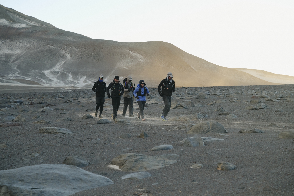
Some 30,000 people climb Kilimanjaro every year, making it one of Africa’s most popular attractions. And as Africa’s highest peak and one of the fabled Seven Summits, the summit is also one of the most challenging attractions to reach! Tanzania’s iconic mountain stands at 5895 metres but despite its intimidating size, conquering it is entirely feasible if you’ve got a good level of fitness and a decent amount of determination. To climb up Kilimanjaro, you’ll need both physical and mental strength, but that rewarding feeling and sense of achievement at the top will be completely worth it.

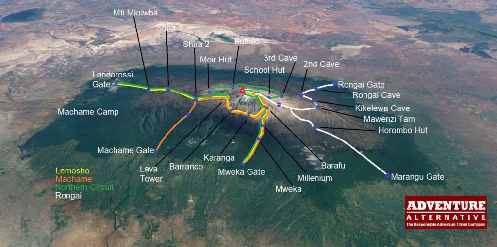
There are nine different routes on the mountain of which seven are ascent routes and two are used for descent. Not all are recommended, one is now shut and quite a few merge with each other, but they do have their own particular pros and cons . Here is a breakdown of each of the routes for climbing Kilimanjaro:
- Machame Route (“Whiskey” Route)
- Lemosho Route
- Shira Route
- Rongai Route
- Northern Circuit Route
- Marangu Route
- Western Breach/Arrow Glacier Route
And there are two routes used for descent. They are:
- Mweka Route
- Umbwe Route
MACHAME ROUTE – HIGHLY RECOMMENDED!
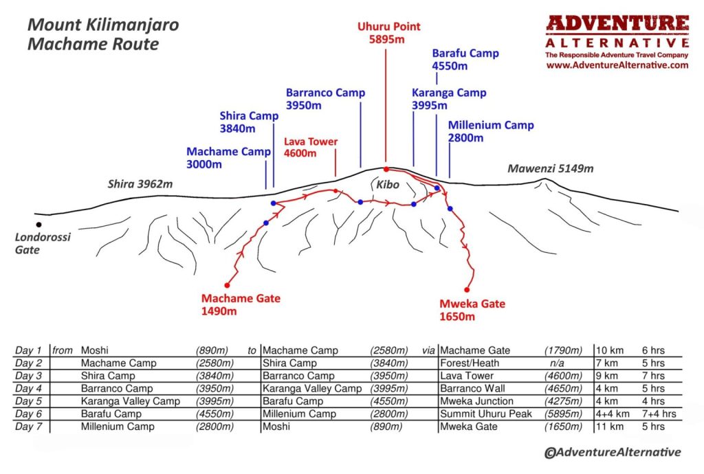
Also known as the Whisky Route, the Machame Route offers excellent acclimatisation because three of the campsites are at the same altitude which is a big benefit to the body as you ‘climb high, sleep low’ which is good mountaineering practise. The route is approximately 62 km/ 37 miles from gate to gate, and the starting altitude at Machame Gate is 1640 metres.
Machame is also the route that provides the most distinctive view of the five ecosystems on the mountain – cultivated farmland, cloudforest (montane), alpine heath, high desert and the glaciated summit. This is a big reason for the popularity of the route. Each campsite is really quite different from the other, and each day is like entering a different world, from the lush jungle to dense forest, then low brush on the vast lava plateau to the surreal world of huge volcanic boulders, followed by the rock and scree on the massif and finally the glaciers on the crater itself.
Machame gives climbers the thrill of a mountain challenge and currently accounts for about 50% of all visitors. It is a camping route and suited to people with plenty of hiking and camping experience, The seven day version is what we recommend and has a very high success rate of about 85%; the most common reasons for descending are tiredness, stomach upset from local food bought in Moshi, and altitude sickness.
This route is physically tough, requiring good fitness and determination especially on the summit night which begins at midnight with a summit at about 8am. It’s entirely possible for beginners to complete the challenge with fitness training and the help of qualified guides.
DAYS:
The recommended time is seven days, with five of those days ascending from the Machame Gate on the southwest side of the mountain. The number of days directly relates to altitude acclimatisation, so we would not consider less than seven days which is the minimum number recommended by the International Climbing and Mountaineering Federation (UIAA).
DIFFICULTY:
This route is mostly strenuous, initially with ups and downs and navigating a succession of valleys and ridges and plateaux and then the unrelenting scree slopes up the central massif to the crater which is quite steep and challenging. However there is nothing technical in the challenge and you are not required to use ropes. Summit morning in the dark can be very cold, icy and windy as it follows a number of zigzags up the rocky slope which is often covered in snow and ice. At the altitude of nearly 6000 metres it will require mental power and good physical health and fitness.
SCENERY:
The Machame Route is a favourite mainly because of the variety of habitats you pass through and the attraction of the flora and fauna, much of which is endemic to the mountain.
What other mountain in the world starts with farms of giant banana trees and coffee plantations into steaming jungle and then cloud forest, and then out of the forest into alpine heath and moorland to the strange volcanic rubble on a bleak plateau, arid alpine desert and finally a glaciated summit which is actually an arctic region at just under 6000 metres right on the equator?
There’s so much variety in the terrain and landscape, with the vastness of the Shira Plateau, the imposing Lava Tower, and the sheer cliffs of the Barranco Wall. Giant groundsel and lobelia loom out of the mist, waterfalls and streams have carved the mountainside into deep ravines and narrow ridges that radiate from the central massif like spokes on a giant wheel. The glaciers glint in the distance, evidence that only 20 years ago the whole massif was snow covered.
PROS AND CONS:
Breathtaking scenery and steady acclimatisation with three nights sleeping at the same altitude are the main benefits of choosing the Machame Route. The paths are well maintained, the campsites have good toilet facilities and the success rate is high.
However with 50% of climbers on this route it is probably the busiest nowadays, depending slightly on time of year. Summit morning can be very busy, especially on a full moon night, and the campsites can be extremely busy with several hundred people spread out.
The distance from Moshi to Machame park gate is about one and a half hours so not too far, and descending the Mweka route means a quick 30 minute journey back into town at the end.
BEST GUIDED TREKS:
Book a 7 day camping trip on the Machame Route with us for £1,895pp. The price includes qualified local guides with UK first aid qualifications and specialised training in high altitude medicine, all accommodation in the hotel and 2 person tents with mattresses, all camping equipment and private toilets plus three meals per day on the mountain.
LEMOSHO ROUTE – HIGHLY RECOMMENDED!
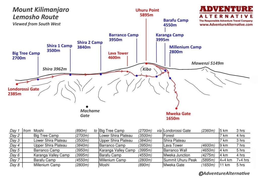
The Lemosho Route begins on the west side of the mountain and is normally an eight day trip but can also be seven days. It merges with the Machame Route on the Shira Plateau which is the second camp, and is popular because the initial ascent through the forest is easier and it adds an extra vital day of acclimatisation if you choose the 8 day option.
Lemosho is a relatively new route and it was designed to absorb some of the busier paths on the other two main routes of Machame and Marangu. The extra day and the slightly easier gradient through the forest makes it a slightly better option for acclimatisation.
The first two days journeys through the Lemosho Glades, which is the rainforest that encircles the mountain at this altitude between 2400 and 3500 metres where you might see Colobus monkey, and plenty of birds on the giant camphorwood trees. The forest thins out and the path climbs onto the vast Shira Plateau which was created during the last eruption an estimated 50,000 years ago. The route then skirts the southern flanks of the mountain, with campsites at Barranco and Karanga Valley both at the same altitude which assist with acclimatisation. Then the path moves up to the final camp at Barafu (“ice” in Swahili) at 4600 metres which is the springboard for the big eight hour push up to the summit through the night.
DAYS:
Allow eight days for the Lemosho Route for the best experience but don’t spend any less than 7 days/6 nights on the mountain so you can acclimatise safely. This is an appropriate time regarded by all guide associations as safe for a mountain of this size.
DIFFICULTY:
The difficulty level is very similar to the Machame Route, with a variety of ups and downs and crossings over valleys and ridges, the dry air of the high plateaux and the unrelenting scree slopes to the crater rim. Camping at altitude is tiring and every day the less oxygen in the air will certainly be evident in your panting and tired muscles.
The first two days of the Lemosho route are easier as the route has less of a gradient through the forest, but it is also longer. Overall this is a benefit, however it is as well to point out that the time to the start gate at Londorossi and doing the park formalities is longer.
SCENERY:
Lemosho is almost the same as Machame route in terms of the scenery with equally as distinctive ‘layers’ of habitat and ecosystems to journey through. The longer trail through the low level forest is particularly attractive and you are more likely to see some wildlife here than on the busier Machame side. The first camps at Mti Kubwa (Big Tree), Shira 1 and Moir Hut are quieter too, so there is a greater impression of remoteness and solitude.
PROS AND CONS:
The additional day on the mountain makes the trip more expensive, but the eight day programme is better for acclimatisation and allows a 90% summit success rate.
The distance to the Londorossi park gate from Moshi or Arusha is longer and you are required to complete the park formalities before then driving further up the trail to the actual hiking starting point. This can mean not starting to walk until the afternoon.
The initial route through the forest is longer and easier, and you are more likely to see some wildlife. After day 3 the route merges with the Machame route which means you will come across the busier campsites at Barranco and Karanga and then Barafu.
BEST GUIDED TREKS:
Book an8 day camping trip on the Lemosho Route with us for £2,245pp. The price includes our qualified local guides, hotel accommodation, 2 person tents and camping equipment, all meals on the mountain and park permits.
SHIRA ROUTE – HIGH STARTING POINT, LESS RECOMMENDED
Approaching Kilimanjaro from the west, the Shira Route shares a lot of similarities with Lemosho. In fact, Shira was the original route and Lemosho was later established as a better and alternative.
But unlike Lemosho which starts at the Londorossi Gate and walks through the beautiful rainforest, Shira Gate at 3600 metres is accessed from a higher point by car, putting your starting point at the Shira Ridge. This means that the trekking journey for most people coming straight off the plane is too much, so it is not really a recommended route except for those who might be previously acclimatised (for example on Mount Meru).
DAYS:
Seven days is recommended for the best acclimatisation and on this route it would be a good idea to spend two nights at the first camp (Simba) to help with that process, or else it’s more likely you will suffer from altitude sickness. Better still would be an eight day option with two nights at the first camp and a further two nights at the next camp on the Shira Plateau followed by the next two camps at Barranco and Karanga being more or less the same altitude. Done this way, Shira route would work well.
SCENERY:
Similar to Lemosho at the start with extensive rainforest, the route eventually joins up with the Machame route with the camps around the base of the summit massif and then the final push on scree and rock to the crater.
PROS AND CONS:
Although you’ll enjoy panoramic vistas with far fewer lesser crowds than Machame or Marangu, the high starting altitude of the gate means that climbers are much more likely to experience altitude-related symptoms on day one. These include headaches and dizziness, nausea and vomiting, fatigue, shortness of breath, or even loss of appetite. If you can overcome this initial jump in altitude and manage additional days to acclimatise then it’s certainly possible to do this route. Also the cost of extra transport getting to the gate means this route is more expensive.
RONGAI ROUTE – BEST FOR RAINY SEASON AND QUIETER TRIP
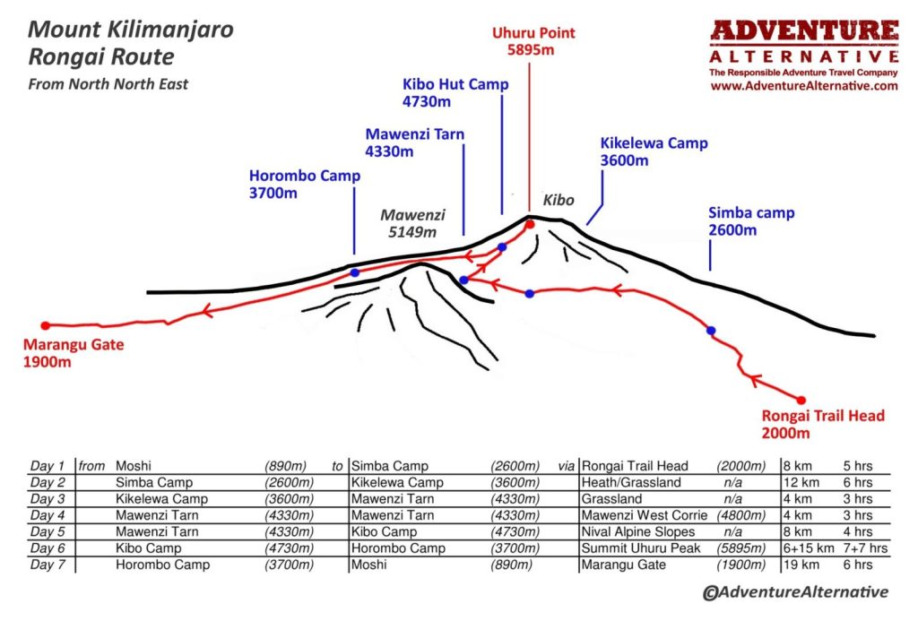
As the only route that approaches the mountain from the north, the Rongai Route is quite different from the others. You will begin your trip from close to the Kenyan border, and journey through areas of wilderness before joining the Marangu Route at Kibo Camp which is at the base of the summit massif. The descent is then on the Marangu Route so this is almost a complete north-south traverse of Kilimanjaro.
The north side experiences lower precipitation, being in the rain shadow, so this trail is ideal for the rainy season as it is more sheltered. It is a much quieter route than the others, mainly because the extra time it takes to reach the gate at the start, so for many people this is their preferred route.
DAYS:
The recommended time is seven days as the optimum time for a good summit success rate, however as ever eight days adds the extra acclimatisation and will increase both the summit rate and the enjoyment of summit day. Therefore for enjoyment and summit success we would definitely recommend eight days.
DIFFICULTY:
This route is considered to be one of the easier routes up Kilimanjaro with a more gradual ascent up to the summit massif. For those with less backpacking and hiking experience, this may be preferred. On summit day itself the route reaches the summit crater at Gilman’s Point further away from the actual summit than the other routes, so psychologically this does make a difference. Having slogged through the night to reach the crater, it is that bit further than people on the Machame/Lemosho route to reach the escarpment to the summit proper.
SCENERY:
While the scenery doesn’t offer as much diversity or share the same wow factor as Machame or Lemosho, it does promise remoteness with some areas of untouched natural beauty. There are more days in the forest and heath, with less distinctive difference between the habitats. You are less likely to experience the eerie lunar-like formations of the high alpine desert but on the plus side it is less likely to be wet.
PROS AND CONS:
Rongai offers a less challenging way up with an easier acclimatisation profile and lower traffic. It’s also the best trail if you’re hiking outside of dry season. The downside is that the views aren’t quite as captivating as the Machame or Lemosho routes, and the extra psychological push needed to get from the crater rim at Gilman’s Point up to the summit.
BEST GUIDED TREKS:
Book a 7 day camping trip on the Rongai Route from £1,955pp. The price includes qualified local guides, accommodation, 2 person tents and camping equipment, plus 3 meals per day on the mountain.
NORTHERN CIRCUIT ROUTE – GOOD IF YOU HAVE MORE TIME
One of the newest routes on Kilimanjaro, the Northern Circuit is also the longest and in many ways the most spectacular because you see so much of what the mountain offers. Due to the additional length of time for acclimatisation, success rates for the summit are higher.
It has the same starting point as the Lemosho Route but deviates north before the Lava Tower, circumnavigating round the north section of the mountain and summitting Uhuru Peak via Gilman’s Point (Marangu and Rongai routes also summit via this point). On this trail you will get an opportunity to journey through the quiet and rarely visited northern slopes, which really give a heightened sense of adventure and remoteness on this mountain which attracts so many hikers every year.
DAYS:
This is a trail that requires nine days as a minimum but can be completed in ten or eleven days if you want more time to enjoy the views.
DIFFICULTY:
In terms of difficulty, the Northern Circuit is similar to the Machame or Lemosho routes. Physical and mental stamina are important as it is a longer trip, but acclimatisation will be better as you have longer to adapt to the less oxygen in the air. It’s a camping route with staff providing the campsite set-up, and on a trip like this you really do get embedded in the outdoor routine. The days vary in length but as usual it’s the long summit day that is the hardest, although on this route it won’t seem nearly as hard on the lungs.
SCENERY:
With fantastic panoramic views and diversity with the different habitats, you will experience everything that is special about Kilimanjaro with the added bonus of having the mountain to yourself most of the time.
PROS AND CONS:
This is considered one of the safer trails in terms of acclimatising as there will be plenty of time to get your body used to the altitudes. You will also get to enjoy 360-degree views with fewer crowds around. Obviously being a longer trip it is more expensive but ultimately, considering this is such an iconic peak which has become one of the great ‘bucket list’ aims in life, the money is definitely worth it.
BEST GUIDED TREKS:
Book a 12 day adventure on the Northern Circuit from £2,445pp. The price includes qualified local guides, accommodation, 2 person tents and camping equipment, plus 3 meals per day on the mountain.
MARANGU ROUTE – RECOMMENDED IF YOU WANT TO SLEEP IN HUTS
The Marangu Route (also known as the ‘Coca Cola Route’) is the oldest and most established route on Kilimanjaro and used to be the most popular. It’s considered to be the easiest way up in terms of gradient and terrain. It is also the only route on the mountain that has huts to sleep in.
However the ascent and descent are done on the same pathway which can mean the route gets busy and the huts can get quite full. However it’s a very useful trail for families and groups looking for the comfort and convenience of a hut, and avoiding having to use the mountain tents. It’s a useful route to do in the rainy season if only to avoid having wet clothes inside a tent.
It’s an easier route with no real difficulties on the path but it doesn’t share the distinctive difference in scenery that you see on the other tracks, The early days on the huge plateau covers open ground and scrub all the way until the final hut below the summit massif. The summit day itself is just the same level of difficulty though, with the same amount of elevation to cover to reach the crater rim at Gilman’s Point and then Uhuru Peak.
DAYS:
Our minimum number of days on Kilimanjaro is always seven days, irrespective of the route, in order to maintain safety parameters and allow for acclimatisation on a mountain that is nearly 6000 metres high. Many people try to climb the Marangu route in less than seven days but this is not to be recommended.
DIFFICULTY:
With a gradual slope, this path is considered to be one of the easier routes on Kilimanjaro.
SCENERY:
The initial days ascend through the steamy forest and band of montane which encircles the whole mountain, and on this route you then spend several days crossing a large plateau and approaching the summit massif directly (as opposed to going round the massif as with Machame and Lemosho). There aren’t the same distinctive variations in habitats, but the views of the summit massif ahead are still beautiful.
PROS AND CONS:
As one of the easier trails this could be suited to climbers with less experience. It’s also the only route with sleeping huts and dormitory-style accommodation, so good for families or groups wanting to avoid the camping experience. The distance from the gate to Moshi is the shortest too, so an easy beginning and end to and from the hotel.
WESTERN BREACH – MOST DANGEROUS ROUTE
This route is now closed by the National Park because the melting of the ice on Kilimanjaro has meant there is now a danger of falling rocks which led to the death of three American climbers In January 2006. Another incident in 2015 led to a near fatality, and since then very few people have climbed this route. The Park will only allow experienced alpinists on this route if they sign a disclaimer and for obvious reasons, local guides are not keen on ascending it.
The breach is a notch in the crater rim and the route is by far the most difficult on the mountain. The approach follows the Machame route and diverts at the Lava Tower to ascend higher to the Arrow Glacier, which has since retreated to a fraction of what it used to be. This change is what now makes the route so dangerous because the gully which used to be tight with ice is now effectively a giant bowling alley with rocks spinning down from a great height and completely invisible at night.
The route reaches an angle of 45 degrees and there are numerous rock steps to negotiate, in fact there is no single route or path to follow, it depends on the conditions on the day you ascend. Nowadays the main aim would be to avoid being exposed to falling rock of course, something which cannot be completely guaranteed unfortunately because back in the day this was the most exciting and dramatic route on the mountain.
UMBWE ROUTE – USED FOR DESCENT
The Umbwe route is the most direct route on the mountain, it ascends steeply through forest up to Barranco Camp on the south side. This means that in terms of acclimatisation it would be the hardest to adapt to.
The Kilimanjaro National Park designated this route to be a descent route some years ago so therefore it’s not possible to ascend the Umbwe route anymore. It’s commonly used by porters to deliver food supplies up to Barranco Camp, and it’s also used a quite retreat for people who are sick at either Barranco or Karanga Camp.
The route is mostly forested, a steep trail that ascends directly up a narrow valley from the roadhead to the Barranco Camp.
MWEKA ROUTE – USED FOR DESCENT
Similar to Umbwe, Mweka Route is only used for descent nowadays and also is on the south side of the mountain. It is the most direct route for people coming off the summit on the Lemosho or Machame routes which use Barafu Camp as their final staging point for the summit.
Coming off the summit, people come back to Barafu for a lunch and then descend directly down the Mweka route to Millennium Camp at the forest line for one more night under canvas. The next morning the Mweka route continues through forest and eventually onto a road to reach Mweka Gate which is where you can get sign out of the park and receive your summit certificate.
Because the roadhead ascends quite a way up through the forest, this route is popular for emergencies on the basis that a jeep or ambulance can make it quite high to pick up an invalid.
Want to find out more about guided tours up Kilimanjaro? Take a look at ourpreferred routes and book your trip of a lifetime from £1895.00 – including accommodation and food, all camping equipment, transport, and all park and campsite fees.
Book Your Adventure of a Lifetime Now
Discover our trips to other Countries
Adventure Alternative Articles
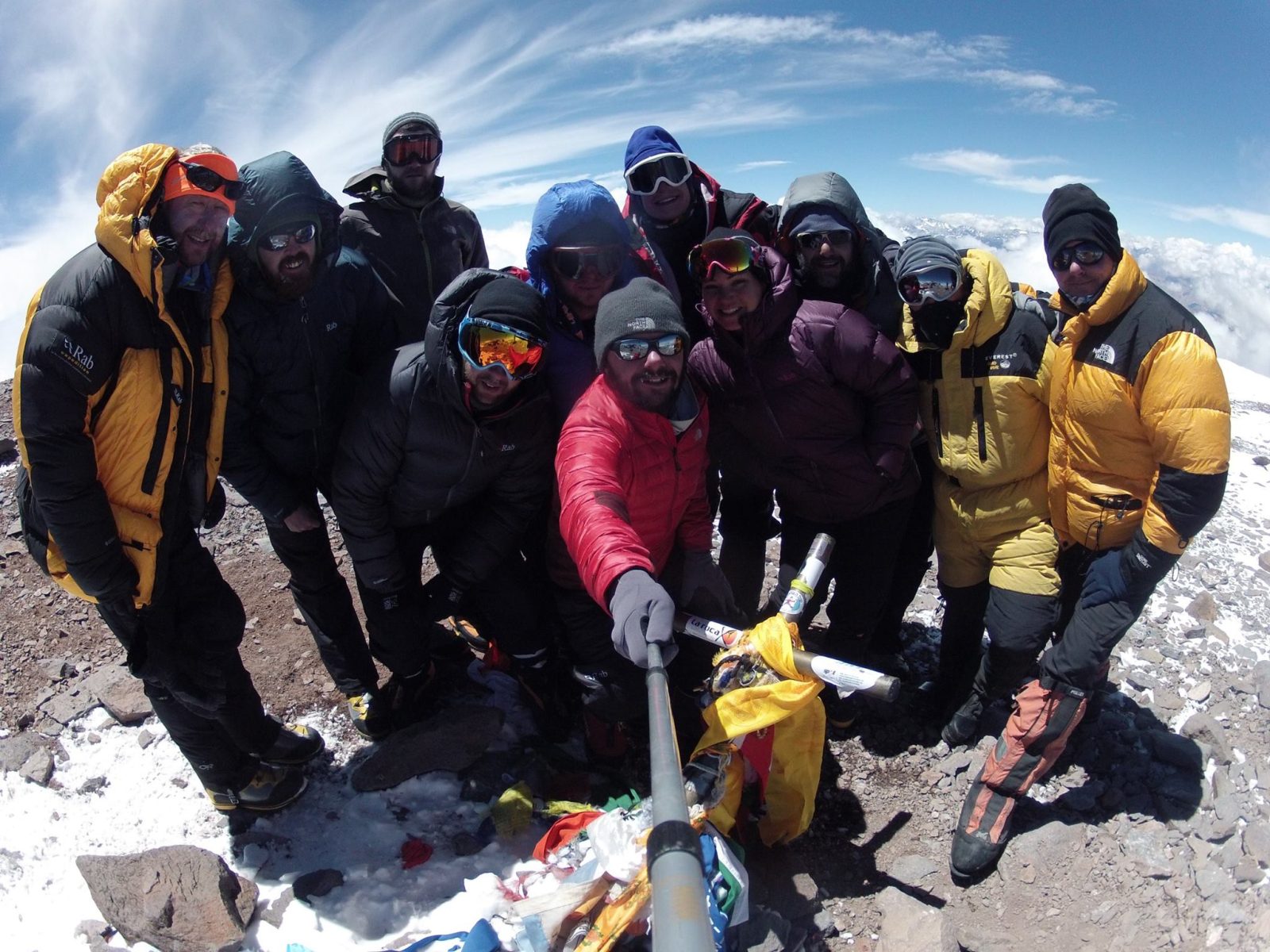
World’s Highest Marathon, Ojos del Salado, Chile
February 2026...after months of planning and organising with BecomingX and our partners High Mountain in Chile, we set off to Copiapo and the...
World Mountain Day
Climbing Calendar Ready for World Mountain Day In celebration of World Mountain Day, we've created a calendar for the year to make it easy for...
Mount Aconcagua Trip Review
January 2016 This year we had a team of twelve clients from four different countries – Iran, Ireland, England, South Africa and Argentina –...