Karakoram Trek to the Base Camps of Five 8000m Peaks
This is a challenging 29 day trek to the base camps of five of Pakistan’s 8000m peaks: K2, Broad Peak, Gasherbrum I, Gasherbrum II and Nanga Parbat via Fairy Meadows.
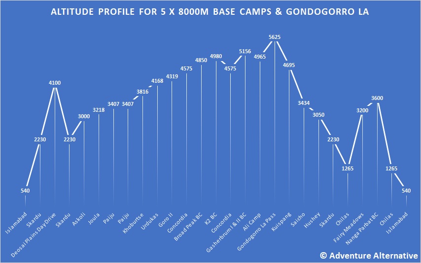
Concordia, famous in it’s own right, has been described as the “Throne Room of the Mountain Gods” for its unique 360˚ panorama of 7,000m and 8000m mountains and the classic impressive views of K2. It also involves a crossing of the semi-technical Gondogoro La pass at 5625 and out through the Hushe Valley to Skardu in order to get to Fairy Meadows.
Highlights
- See five of the Karakoram’s 8000m peaks from their base camps
- Trek beneath and explore around the Gasherbrums, Masherbrum, Broad Peak, Trango Tower, Cathedral Peaks, Mustagh Tower and Chogolisa amongst many others
- Trek along the mighty Baltoro Glacier and reach the famous location of Concordia
- Cross the famous Gondogoro La (5625m) pass
- Relax and enjoy the lush green serene plateau of the Fairy Meadows
- Experience once of the classic journeys from Islamabad to Skardu and up into the mountains

The Karakoram
Here is a short clip from independent traveller Bilal A that perfectly captures the essence and beauty of this region of the Karakoram.
Itinerary of the Karakorum Trek to Five 8000m Base Camps
Please note that the itinerary given is the outline plan. However, we will be travelling in a high mountain environment with a number of unknown influences including weather and rates of acclimitisation of different individuals. Therefore the itinerary is flexible to some extent to allow our leaders to make appropriate decisions on the ground based on prevailing conditions. In particular the crossing of the Gondogoro La can be difficult and becomes impassable in bad weather or following heavy snow, in which the trek has to continue back the way it came.
Arrival Islamabad, transfer to hotel for relaxation.
Fly or drive to Skardu, which is located in the heart of the mountain region of Baltistan. The flight has great views of the Karokorum range. Skardu lies at the edge of a broad floodplain that is the confluence of the Indus, Shyok and Basha rivers. Overnight in a hotel. If flight is not possible due to bad weather then drive along the Highway over two days.
Skardu to Askole – the is only 96 kms but the road is bad. We use jeeps and end up at a campsite in Askole at the end.
In the morning we’ll attend an official briefing by the tourism department regarding our trek in the Karakoram National Park. After this we’ll have some free time for final kit check and if needed we can buy anything that’s needed. If times allows we can also visit Katchura Lake and Skardu fort. The view from the fort is stunning, with Skardu city and the Indus River framed by the Karakoram Range.
An easy day to start the trekking, easy path following valley floor and alongside the river.
A moderately more difficult trek to day, following valley floor on easy paths.
Continuing along the Braldu valley, which opens up to reveal the Mighty Biafo glacier that flows from the Hispar Pass and Snow Lake into the valley. Biafo Glacier is a massive 67 km long glacier and is the world’s 3rd longest glacier outside of the polar regions. We’ll have our first experience of moraine walking as we cross the snout of the glacier to reach Korophong and our lunch spot beside the river which makes today harder than before.
Continue along the Braldu River to reach the Paiju campsite, gaining altitude gradually. You may glimpse the Masherbrum Range along the south side of Baltoro Glacier and later in the day the Trango Towers.
Approaching the Baltoro glacier, the ice rises over 70m above the river at it’s snout. The glacial moraine can be difficult to navigate and this is a hard days walking with stream crossings. From this point there are uninterrupted views of Paiju Peak (6,610m), Uli Biaho Tower (6,109m), Trango Towers (6,363m) and Cathedral Peak (6,024m) and behind are the contrasting steep grassy grazing pastures of the ibex. Cross the Liligo glacier, which flows from the south of the Baltoro glacier, and reach the campsite which is opposite the Trango Towers.
Today is a short trek in distance but strenuous at this altitude. Crossing two glaciers and passing Cathedral Peak and Trango Towers, and onto the campsite which is perched on terraces that were originally used by the Duke of Abruzzi’s expedition in 1909.
The views from the campsite have to be amogst the best campsite views in the world as Concordia affords a central position with views towards many of the great peaks.
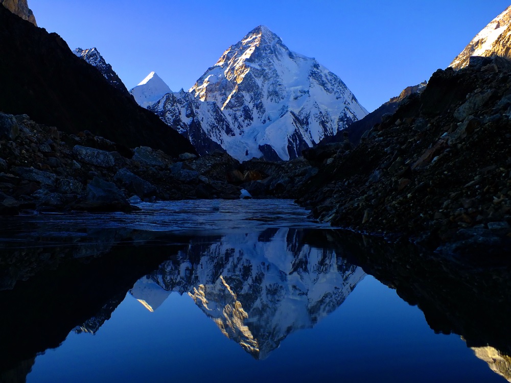
Follow the moraine along the edge of the glacier before crossing to the centre of the glacier with Masherbrum (7,821m) to your right and the Yermamendu glacier flowing from the south. Constantly ascend and descend the piles of rocky rubble which are scattered over the ice. Ahead are the peaks of Concordia, including the stunning Broad Peak and Gasherbrum IV. The trek visits K2 base camp and then ends up at the nearby Broad Peak base camp.
After leaving campsite, the Biange glacier to the north provides a spectacular view of Muztagh Tower (7283m), which is considered one of the most technical mountains to climb in the Karakoram. Here are also the famous “Ice Cubes” of Baltoro glacier, ice towers or seracs rising 40-60 meters out of the glacier.Mitre Peak (6070m) is on the right, with Baltoro Kangri (7300m) beside it, while the Gasherbrum Group will be directly ahead. The expanse of Broad Peak (8052m) is to the left and the mighty K2 (8611m) looming above the ridge as it towers over the Godwin Austen Glacier.
This day can be used to adapt to any bad weather from the previous days and ensure that all the base camps are seen.
This camp is at the base of the Gondogoro Pass.
This is a tough ascent over the pass depending on conditions, which might at this point require the team to retreat back the same way to Askole. If it’s okay then the climb up on rock is challenging and from the top the descent is down to Khuspang at 4695m.
This day will soak up any bad weather previously and allow for the trek to continue as planned. If all the days are used then today is a rest day.
Accomodation in a hotel at the KKH.
This is the famously beautiful trek on the way to Nanga Parbat. After breakfast drive (4×4 jeep) to Tato Village 1 hour away. From here, Fairy Meadows is a gentle 3 hr trek, a popular trekking destination due to the views of one of the most beautiful mountains anywhere in the world, Nanga Parbat, which is also the 9th highest mountain in the world and the 2nd highest mountain in Pakistan. Overnight in a comfortable cottage.
Walk out and drive to the hotel in the town of Chilas.
Ready for an Adventure to the Karokoram?
We offer this trip as a private expedition to groups of 3 or more, and the season is in July. Please contact us to make the arrangements with our partner in Pakistan which will provide all the staffing and organisation for this trip. Once the dates have been agreed then we will create a booking link below so you can confirm the trip.
Bookings for this trip have to be made at least two months in advance in order to prepare everything, including the paperwork which takes considerable time. We will require copies of your passport and passport photos.
All travellers must be protected by insurance that covers cancellation, accident, health, emergency evacuation up to USD$20,000 (this needs to be specificed in the policy which is checked by the authorities before issuing any permits), loss or damage to baggage and personal effects. We recommend specialist agencies such as Campbell Irvine, the BMC, Austrian Alpine Club or True Traveller.
Fixed Itineraries
No upcoming trips found.